This page provides a comprehensive and impartial guide to climbing Kilimanjaro via the Northern Circuit.
Northern Circuit Kilimanjaro Route
The Northern Circuit, as the newest and longest route up Kilimanjaro, links together portions of several other routes. It is operated as an eight- or nine-day trek by most tour operators.
Success rates are relatively high for this route because trekkers have plenty of time to acclimatise.
Beginning in the West, the Northern Circuit follows the same route as the Lemosho Route for the first two days before veering north towards Lava Tower and around to the eastern side of the mountain.
Trekkers reach the crater rim at Gilman's Point and traverse around to Uhuru Peak before descending via either the Mweka or Marangu Route.
Typical Itinerary for Northern Circuit
The Northern Circuit Route is operated as an eight-day or a nine-day trek. Below is a detailed itinerary for the nine-day route. For details on the eight-day variation, see the Route Variations section below.
Day 1
- Distance: About 5.5km, or 3 miles
- Trekking time: 3 to 4 hours
- Change in elevation: 460 meters
- Landscape: Rainforest
The Northern Circuit Route starts at the same point as the Lemosho Route, far on the western side of Kilimanjaro. The first day of trekking begins with a two-hour drive from Moshi, or a longer drive from Arusha, to Londorossi Gate (2,100 meters), where trekkers will be introduced to their crew, which includes guides, porters and cooks. Packs are weighed to ensure they don't exceed 20 kilograms, and the porters arrange all the gear needed for the days ahead.
After checking in at the park gate, trekkers will get back into the car to travel to the trailhead, which is a further 12 kilometers. This portion of the drive can be muddy and inaccessible during the wet season, so trekkers may have to walk a portion of this distance. Assuming the road is passable, then the day's trek is a short one, with about 460 meters of elevation gain to Mti Mkubwa Camp (2,820 meters).
Trekkers should keep their eyes peeled on the way - it is possible to see elephant or buffalo on this portion of the trail, and your group may be accompanied by an armed guide for protection! Trekkers arrive to the welcome sight of a fully-assembled camp, and dinner is served.
Day 2
- Distance: About 8km, or 5 miles
- Trekking time: 5 to 6 hours
- Change in elevation: 790 meters
- Landscape: Rainforest: Low Alpine
Day Two sees trekkers making their way from Mti Mkubwa Camp (2,820 meters) to Shira Camp 1 (3,610 meters). The relatively short hike takes you through scenic rainforest which gives way to low alpine meadows and moorlands.
Day 3
- Distance: About 7km, or 4 miles
- Trekking time: 3 to 4 hours
- Change in elevation: 240 meters
- Landscape: Low Alpine: High Alpine
On Day Three, trekkers have a short hike from Shira Camp 1 (3,610 meters) to Shira Camp 2 (3,850 meters). At Shira Camp 2, trekkers are rewarded with their first views of the Kibo summit, and Mount Meru is visible in the East. Temperatures can drop quite significantly here on the plateau, so trekkers should be prepared.
Please Note: On the eight-day route, trekkers will continue past Lava Tower (4,600 meters) and drop down to Moir Camp (4,200 meters), where they will spend the night.
Day 4
- Distance: About 14km, or 8 miles
- Trekking time: 5 to 7 hours
- Change in elevation: 750 meters ascent; 400 meters descent
- Landscape: Low Alpine; High Alpine
Trekkers climb up to Lava Tower (4,600 meters) on the morning of Day Four, where they will have lunch before descending to Moir Camp (4,200 meters) where they will sleep. This is a classic acclimatisation day, allowing hikers to "climb high and sleep low" in preparation for the summit bid in a few days' time.
Day 5
- Distance: About 12km or 7 miles
- Trekking time: 5 to 7 hours
- Change in elevation: 180 meters descent
- Landscape: High Alpine
A steep climb takes hikers out of Moir Camp (4,200 meters) in the direction of Buffalo Camp (4,020 meters). A short detour out of Moir Camp leads trekkers to the summit of Little Lent Hill (4,375 meters). Trekkers should have some time to relax after arriving at camp in the afternoon.
Day 6
- Distance: About 8km, or 5 miles
- Trekking time: 5 to 7 hours
- Change in elevation: 220 meters descent
- Landscape: High Alpine; Low Alpine
On Day Six, trekkers continue hiking east around the northern edge of the mountain from Buffalo Camp (4,020 meters) towards Rongai Third Cave (3,800 meters). It is a further acclimatisation day with some downtime in the afternoon.
Day 7
- Distance: About 15km, or 8 miles
- Trekking time: 4 to 5 hours
- Change in elevation: 1,000 meters
- Landscape: High Alpine; Glacial
Day Seven marks a transition from the hillside traverse of the last few days to a steady ascent. Trekkers will hike from the Rongai Third Cave (3,800 meters) through the Saddle between Kibo and Mawenzi Peak towards School Hut (4,800 meters). Try to get to bed early -- you'll be awoken before midnight to start your summit attempt! Prepare your gear before bed, including preparing some warm clothes, snacks, insulated water bottles and your headlamp.
Day 8
- Distance: About 6km, or 3.5 miles ascent; 10.5km or 6 miles descent
- Trekking time: 6 to 8 hours ascent; 4 to 6 hours descent to Horombo Hut
- Change in elevation: 1,095 meters ascent; 1,945 meters descent
- Landscape: Glacial; High Alpine; Low Alpine
Day eight begins early -- before midnight, in fact. The porters will offer you some hot tea and biscuits before you begin your summit bid. A steep slope leads from School Hut (4,800 meters) to the first checkpoint at Hans Meyer Cave (5,150 meters). After several switchbacks, trekkers then arrive at Gilman's Point (5,681 meters) on Kibo's rim. Take some time here to have a snack and gather your strength for the final push to the summit of Uhuru Peak, only 200m of altitude higher. For many people, this last stretch of trail before the summit is the most difficult of the entire trek -- but is also the most rewarding, as you will discover as you soak in the view from the highest point in Africa.
The descent is long and arduous, so it's best not to spend too long on the summit. You will backtrack to Stella Point and follow the same route down the mountain as those who have climbed to Uhuru Peak via the Machame Route. After a long descent, you will arrive at Barafu Camp (4,680 meters) where you will typically have a short break before continuing on to Millennium Camp (3,950 meters) where you will spend the night. (Alternatively, some tour operators choose to descend via Gilman's Point and Horombo Hut on the Marangu Route.)
Northern Circuit Pros and Cons
Pros
- Can be completed on an 8- or 9-day route variation. Both have great summit success rates!
- Great Walk High, Sleep Low profile which aids acclimatisation
- Quiet and remote route, ideal if you want to avoid crowds and have the mountain to yourself
Cons
- The longest route in days and distance. This means trekking fatigue is quite common
Northern Circuit Altitude Profile
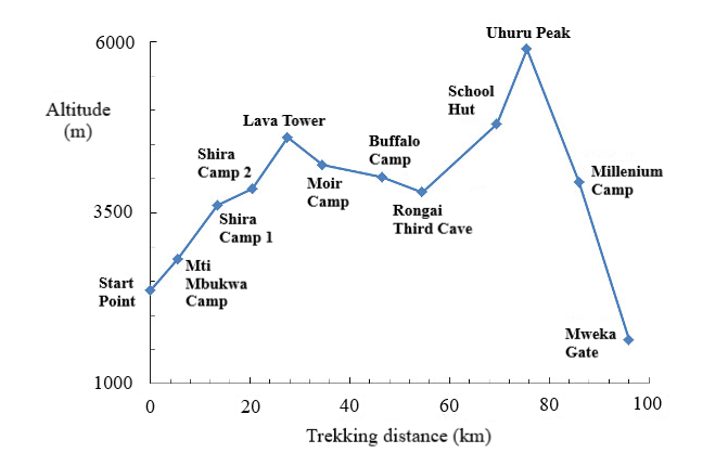
The schematic diagram below shows the altitude profile for the Northern Circuit.
The route initially ascends to Lava Tower, but then gradually descends to Rongai Cave. This provides good time to acclimatise for the summit push.

Kilimanjaro Northern Circuit Route FAQ
When is the best time to trek the Northern Circuit?
June to September is the best time to hike the Northern Circuit on Kilimanjaro. That said, since it is close to the equator it is possible to climb the mountain at any time of the year. April and May are the rainy season, so most hikers avoid these months. November is a light rainy season but the Northern side is in the rain shadow so you should be fine to trek in this month.
How difficult is the Northern Circuit?
The Northern Circuit route offers trekkers ample time for acclimatisation, therefore it can be considered easier than some of the shorter routes. That said, you will be hiking nearly 100km over the course of eight or nine days, which is not an easy task. It's a good idea to work on your aerobic fitness before taking on the trek.
Is altitude sickness a risk on the Northern Circuit Route?
The Northern Circuit is designed to allow hikers some time for acclimatization before the summit push. That said, altitude sickness is a serious concern and trekkers should be informed of the risks, symptoms and warning signs before they go. We recommend you read our detailed article on Altitude Sickness and Acclimatisation. If you are particularly concerned about altitude sickness, the nine-day Northern Circuit is probably your best chance to reach the summit as it allows ample time for acclimatization.
How much does the Kilimanjaro Northern Circuit Route cost?
On average, the cost of a standard Northern circuit hike on Kilimanjaro is about $2500. The costs of trekking on the Northern Circuit Route will vary based on a few factors, such as what season you choose to hike, whether you choose the eight-day or nine-day option, or whether you choose to use a Western guiding company or communicate directly with a local guiding company.
Here are the major costs to consider when planning to undertake the Northern Circuit:
- Visa, Vaccinations, Insurance etc: ~$300-$500
- Equipment (buying and hiring): ~$200-$300
- Flights to Kilimanjaro International Airport: ~$800
- Tour Agency: About $2,000 for a cheap local agency to ~$4,000 for an expensive Western agency.
- Tips: ~$200-$300
- Misc (additional food, unplanned travel / hotels etc): $200
- Total Costs: $3,500 – $6,000
What gear do I need for the Northern Circuit?
Trekking Mount Kilimanjaro requires a number of essential pieces of trekking clothing and equipment. You will be exposed to a range of altitudes where temperatures fluctuate dramatically between night and day. To help you plan and prepare for your trek, we have written a detailed Kilimanjaro gear list.
Are permits required for the Northern Circuit of Kilimanjaro?
A permit is required to climb Kilimanjaro. Furthermore, all trekkers must be accompanied by a guide and porters. If you are joining an organised tour, these will be arranged for you.
Are there alternative routes for climbing Kilimanjaro?
Yes, there are. I highly recommend the Machame and Rongai as alternative routes to climbing Mount Kilimanjaro. This is because they offer great views of the unspoilt Tanzanian wilderness and are also great options for combined climbs through both Tanzania and Kenya.
Continue browsing
See more information on Tanzania. Or check out these other Kilimanjaro Hiking articles:

